


National Geographic Northville-Placid Trail T.I. Topographical Map (736)
- In stock, ready to ship
- Inventory on the way
- 1% of every sale is donated to an environmental organization in need
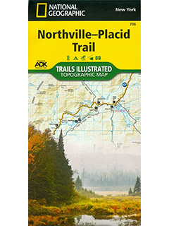
National Geographic Northville-Placid Trail Map # 763 – this map of the Northville-Placid Trail combines unmatched detail with helpful information to offer an invaluable tool for making the most of your visit to this 130 plus mile long trail. The Northville-Placid Trail (NPT) is the jewel in the crown of the Adirondack Park trail network. The NPT was constructed in 1923 through remote lake country. The map is expertly researched and created in partnership with the Adirondack Mountain Club (ADK).
This map can guide you off the beaten path and back again through the wildest and most remote sections of the 6.1 million acre Adirondack Park. The trail is commonly traversed from south to north with hikers starting at Northville in the Shaker Mountain Wild Forest. From there hikers travel through the Silver Lake Wilderness then past Piseco Lake and into the West Canada Lake and High Peaks Wilderness areas. The northern terminus of the trail is near the town of Lake Placid, home to the 1980 Winter Olympics. Along the way the numerous features are shown including shelters, designated backcountry campsites, and stream crossings.
- Orders over $200 qualify for free standard shipping! Some exclusions apply.
- Choose from standard, priority, or express shipping at checkout. (Please note express shipping is unavailable on the weekend days)
- Oversized items (such as skis and snowshoes) require a higher shipping rate due to their size and weight.
- We ship USPS to the U.S. only.
- Local to Saratoga Springs? Select in-store pickup at checkout!
For shipping and return details, please see our return policy.
Please contact us with any other questions at info@saratogaoutdoors.com!